
Raindrop Trace
Overview
The raindrop trace process (nldi-flowtrace) follows an elevation surface
downstream from a user-supplied coordinate to the nearest valid NHDPlusV2
flowline. It is used internally by the NLDI
hydrolocation and basin
endpoints and
is also available as a standalone OGC API Process.
How the Algorithm Works
When a point is provided to the raindrop trace process:
- The algorithm samples elevation data around the input coordinate.
- The algorithm follows the direction of steepest descent downstream.
- The trace continues until it intersects a valid NHDPlusV2 flowline.
- The resulting intersection location becomes the hydrologic reference point.
This ensures that the flowline found is within the local catchment of the selected point, rather than one that is nearby in Euclidean space but belongs to a different catchment.
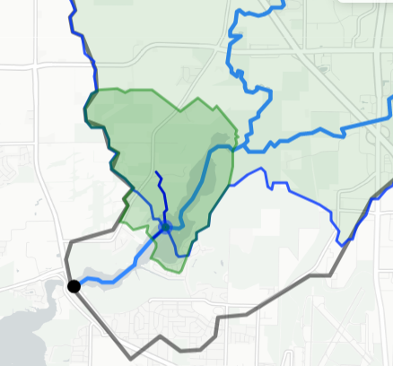
The figure shows a raindrop trace (dark blue) following the elevation surface to intersect an existing flowline (lighter blue). The green polygon is the local NHDPlusV2 catchment; the faint green area with blue border is the custom drainage basin derived for that intersection point.
Relationship to Hydrolocation
The NLDI hydrolocation endpoint behaves as follows:
- If the given point lies within 200 meters of a flowline, it is snapped directly.
- If not, the raindrop trace algorithm determines the downstream path to the appropriate flowline.
This ensures that hydrolocations are always associated with the correct catchment and are not misassigned to nearby but hydrologically unrelated tributaries.
See Basin and Hydrolocation for details on how raindrop trace integrates with basin delineation.
Example Request
Trace from a point near Madison, WI to the nearest flowline, returning the complete NHD flowline and the raindrop path:
POST https://api.water.usgs.gov/nldi/pygeoapi/processes/nldi-flowtrace/execution?f=json
Content-Type: application/json

{
  "inputs": {
    "lat": 43.0864,
    "lon": -89.35,
    "direction": "none"
  }
}
Set direction to "up" or "down" to receive only the upstream or
downstream portion of the intersected flowline. Use "none" (the default)
for the complete flowline.
The response includes GeoJSON features for the NHD flowline (or its
upstream/downstream portion). If the input point does not already lie on a
flowline, the response also includes a raindropPath geometry showing the
traced path.
Explore the Full Parameter Schema
The pygeoapi process description provides the complete parameter schema,
including input types and output descriptions:
/processes/nldi-flowtrace?f=json